
For operators, buyers and attorneys
In the Permian, the same acre can have different owners at different depths. I follow every depth limit through the leases, assignments and releases, and tie them to the wells that hold them.
What I deliver
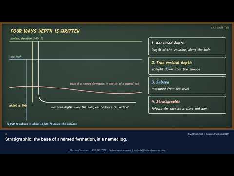
- Depth descriptions read exactly as written: measured, true vertical, subsea or stratigraphic
- Retained acreage and continuous development clauses, with the deadlines worked out
- Well and completion records from the Railroad Commission or OCD to show what each well holds
- A per-depth ownership schedule for each tract
Common questions
How do you know which depths a well holds?
From the lease and its Pugh or retained acreage language, read together with the completion records and the producing interval reported to the state.
Watch and learn


I am a landman, not an attorney. My work is title research and ownership analysis; legal opinions come from your attorney.
Public data on this page comes from government agencies (Railroad Commission of Texas, New Mexico Oil Conservation Division, Bureau of Land Management, U.S. Energy Information Administration), Baker Hughes and company releases, as named where each figure is shown. LMJ Land Services is not affiliated with any agency or company named on this site.
AI disclosure: This page was compiled with help from B27 Intelligence, the AI-assisted research system of LMJ Land Services, and reviewed by Michele Johnson. Automated systems can make mistakes; confirm any record, link or figure at its official source before relying on it.